An on-line trail map, including designated parking, is available at: https://empiretrail.ny.gov/.
The Greenway has created ten formal Trailhead Parking Areas along the 36-mile AHET trail route. The AHET Trailheads are detailed below, listed “north to south” along the trail.
Rensselaer County
1. Rensselaer Riverfront Park Trailhead (20 parking spots)
• Address: Broadway, Rensselaer, NY 12144
2. East Greenbush Clinton Street Trailhead (11 parking spots)
• Address: Intersection of Clinton St. and Columbia Turnpike (Route 20) East Greenbush, NY 12061
3. Schodack/Nassau Lake Trailhead (13 parking spots)
• Address: County Route 7, Nassau, NY 12123
4. Village of Nassau Trailhead (30+ parking spots)
• Address: Village Commons Park, John Street, Nassau, NY 12123
Columbia County
5. North Chatham Trailhead (10 parking spots)
• Address: Depot Street, North Chatham, NY 12132
6. Niverville Trailhead (11 parking spots)
• Address: Intersection of State Route 203 and Main St (County Route 28) Niverville, NY 12130
7. Valatie Route 9/9H Park & Ride Lot (50 parking spots)
• Address: Intersection of State Routes 9 & 9H, Valatie, NY 12184
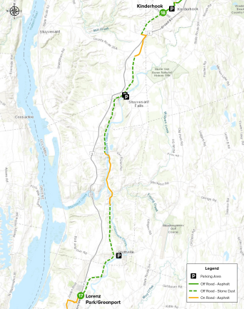
8. Village of Kinderhook Trailhead – Rothermel Park (33 parking spots)
• Address: Village Playground, Rothermel Ave, Kinderhook, NY 12106
9. Stuyvesant Falls Trailhead (4 parking spots plus 20 spots on east side of bridge)
• Address: County Route 25A (Hudson Ave), Stuyvesant Falls, NY 12174
10. Stottville Park Trailhead (15 parking spots)
• Address: Little League Field, Atlantic Ave, Stottville, NY 12172